
U.S. BUREAU OF LAND MANAGEMENT
Mining claims + land management
BLM MLRS contributes Mining Claims — Not Closed records and mapped geometry where available. BLM Colorado Surface Management Agency data supplies land-management context.
COLORADO · MINING CLAIMS · MINERAL RESEARCH · OFFLINE GPS
Colorado prospecting runs from the placer-gold country that drew the 1858 rush into old hard-rock districts, pegmatite country and mineral belts spread across the Rockies. The state is also known for aquamarine, rhodochrosite, amazonite, topaz, smoky quartz and many other collectible minerals. GroundRove combines current BLM mining-claim records, mineral evidence, Colorado geology, historic mines and land status so you can research an area before you drive out to it. Save the ground you want to inspect and carry the same map and research offline.
FOUNDING OFFER
Comparable paid mapping apps are roughly $40–$100/year.
Future GroundRove upgrades included · No annual GroundRove membership fee
Colorado and Arizona are included now. Founding Access also covers future planned state expansions.
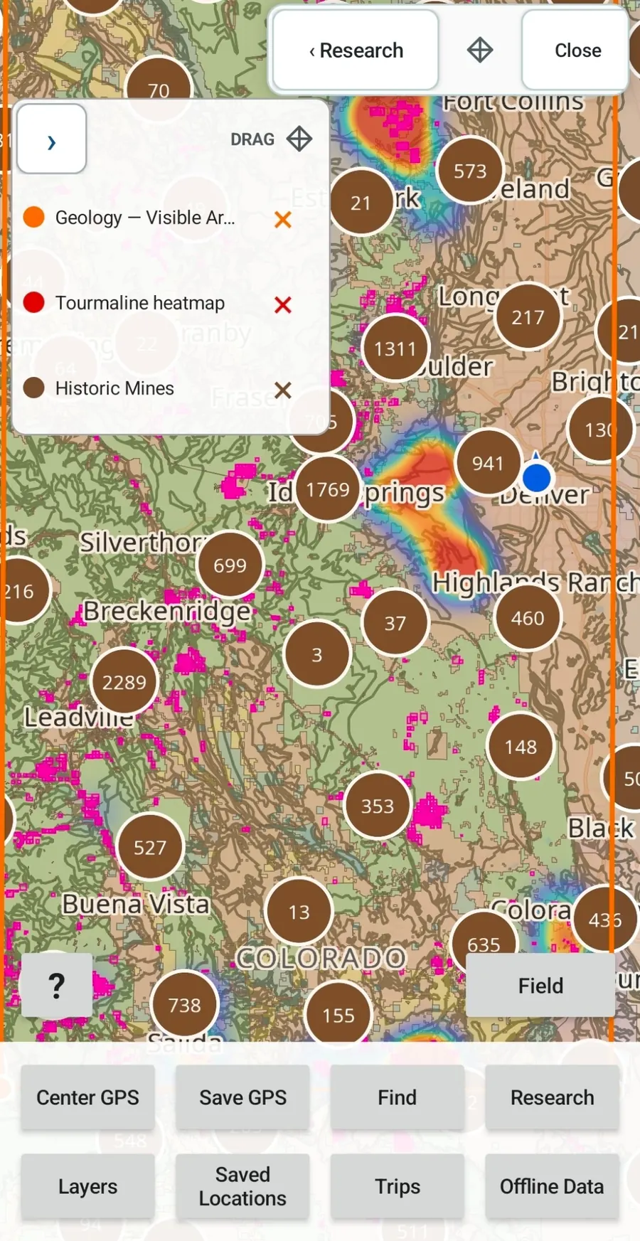
COLORADO PROSPECTING RESEARCH
Colorado has more than thirty gemstone varieties and a mining record that reaches from Front Range placer and hard-rock districts to the San Juans, central mountain camps and scattered mineral occurrences across the state. Famous localities are useful reference points, but they are only part of the picture. GroundRove lets you start with a mineral, a geologic unit, an old district, a drainage, a mountain range or any area on the map, then compare the evidence with geology, mine records, land status and current claim context.
BLM MINING CLAIMS + LAND STATUS
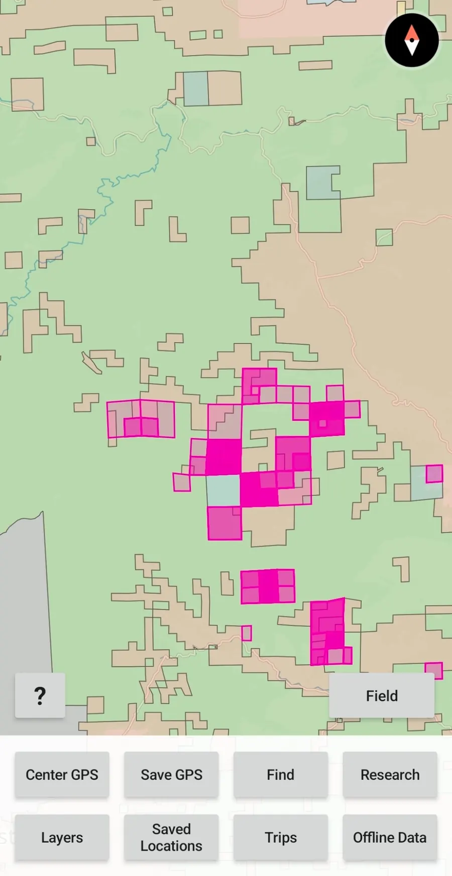
Colorado’s historic mining districts and mineralized belts still contain extensive claim activity. GroundRove puts BLM MLRS mining-claim records on the same map as the geology, mineral evidence and historic mine records you are researching.
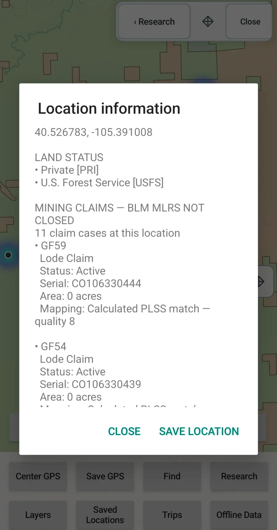
Tap a location to inspect available claim details, including claim type, status, serial information, acreage and mapping-quality information.
Claim geometry is research context, not a surveyed legal boundary. Land status does not independently establish legal access or collecting permission.
FOUNDING OFFER
Get lifetime GroundRove access for $55 once. Colorado and Arizona are included, along with future GroundRove upgrades. Try GroundRove free for 7 days; after purchase, you have 7 days to request a 100% refund.
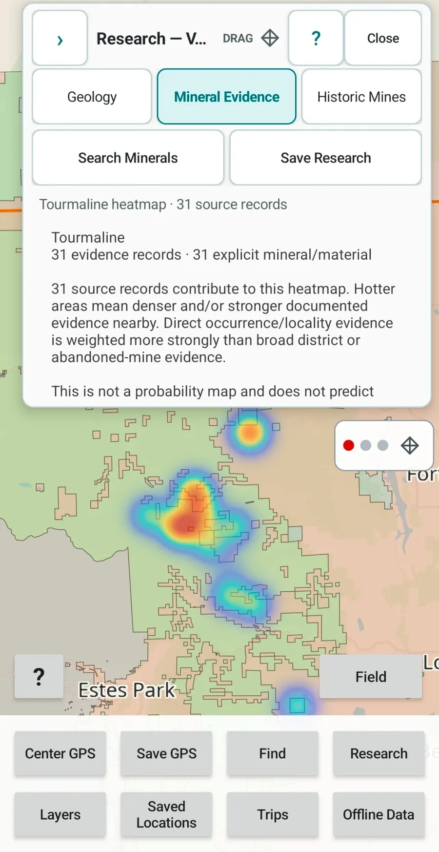
MINERAL EVIDENCE RESEARCH
Colorado’s documented mineral record includes placer and lode gold, aquamarine, rhodochrosite, amazonite, topaz, smoky quartz, garnet, fluorite and many less familiar occurrences. Aquamarine is concentrated in high-elevation pegmatite country around Mount Antero, while rhodochrosite is closely associated with the Alma mining district. Those famous examples sit inside a much larger statewide record.
Choose a mineral or material and analyze the area on your screen. GroundRove turns installed source records into a geographic evidence heatmap, then lets you open the underlying records and compare them with geology, historic mining activity, claims and land status.
Mineral Evidence shows documented evidence. It does not predict that you will find a mineral at a location, and it does not establish permission to collect.
The Founding Access is $55 once for lifetime access. Start with a 7-day free trial; after purchase, you have 7 days to request a 100% refund.
SIDE BY SIDE
Some rockhounding tools focus on established localities. GroundRove is built around the surrounding ground: mineral evidence, geology, historic mines, BLM mining claims, land status and offline field use.
The full table sits here—after the core research differentiators and before the rest of the field workflow and the Founding Access details.
GroundRove feature names below match the labels used in the app wherever possible.
| Capability | GroundRoveGroundRoveFounding Access | RockHoundRRockHPro | RockdRockdFree | MindatMindatFree | onX BackcountryonX BCElite | Gaia GPSGaiaPremium | OsmAndOsmAndPro | Avenza MapsAvenzaPlus | CalTopoCalTopoPro | BaseMapBaseMapPro | LandGlideLandGPersonal | onX HuntonX HuntPremium · 1 state |
|---|---|---|---|---|---|---|---|---|---|---|---|---|
| Dedicated mobile app | ✓ | ✓ | ✓ | — | ✓ | ✓ | ✓ | ✓ | ✓ | ✓ | ✓ | ✓ |
| Comparable price | $55 oncelifetime access*7-day free trial | $49.99/yrPro† | Freeno paid tier | Freemembership free | $99.99/yrElite‡ | $59.99/yrPremium | $39.99/yrPro · US App Store | $34.99/yrPlus§ | $50/yrPro | $39.99/yrPro | $99.99/yrPersonal | $34.99/yrPremium · 1 state¶ |
| Analyze visible mineral evidence | ✓ | — | — | ◐ | — | — | — | — | — | — | — | — |
| Search minerals / materials | ✓ | ✓ | — | ✓ | — | ✓ | ↗ | ↗ | ↗ | — | — | — |
| Mining claims | ✓ | ◐ | — | ◐ | — | — | ↗ | ↗ | ↗ | — | — | ◐ |
| Historic mines & prospects | ✓ | ◐ | — | ✓ | — | ✓ | ↗ | ↗ | ↗ | — | — | — |
| Colorado geology | ✓ | ◐ | ✓ | ◐ | — | ✓ | ↗ | ↗ | ✓ | — | — | — |
| Search & explore geology | ✓ | ◐ | ✓ | ◐ | — | ◐ | ↗ | ↗ | ◐ | — | — | — |
| Analyze current map area | ✓ | — | ◐ | ◐ | — | — | ↗ | ↗ | — | — | — | — |
| Geology filters | ✓ | — | ◐ | ◐ | — | — | ↗ | ↗ | — | — | — | — |
| Geology + Mineral Evidence | ✓ | ◐ | — | ◐ | — | ◐ | ↗ | ↗ | ↗ | — | — | — |
| Research results on the map | ✓ | ◐ | ◐ | ◐ | — | — | ↗ | ↗ | — | — | — | — |
| Land management | ◐ | ◐ | — | — | ◐ | ✓ | ↗ | ↗ | ✓ | ✓ | ✓ | ✓ |
| Offline maps + GPS | ✓ | ✓ | ◐ | ◐ | ✓ | ✓ | ✓ | ✓ | ✓ | ✓ | ✓ | ✓ |
| Track & backtrack + saved field data | ✓ | ◐ | ◐ | ◐ | ✓ | ✓ | ✓ | ✓ | ✓ | ✓ | ◐ | ✓ |
| Import / export data | ✓ | ◐ | — | — | ◐ | ✓ | ✓ | ✓ | ✓ | ◐ | ◐ | ✓ |
Prices and features checked August 30, 2026. Plan details and promotions may change. “Not documented” means no comparable feature was verified.
THE REST OF THE MAP IS STILL THERE
GroundRove Founding access is $55 once for lifetime access. Colorado and Arizona are included, along with future GroundRove upgrades.
OFFLINE GPS + FIELD TOOLS
GroundRove’s Colorado basemap and installed research datasets stay on your phone. GPS and field tools keep working without cellular service, which is useful on mountain roads, in high basins, along remote Forest Service routes and across large public-land areas.
OFFLINE IN COLORADO
$55 once keeps GroundRove for life, including future upgrades and offline field tools. Start with a 7-day free trial; after purchase, you have 7 days to request a 100% refund.
COLORADO GEOLOGY
Colorado exposes roughly 2.7 billion years of geologic history, from the High Plains through the central Rockies to the western canyon country. That range is part of why mineral occurrences vary so much across the state.
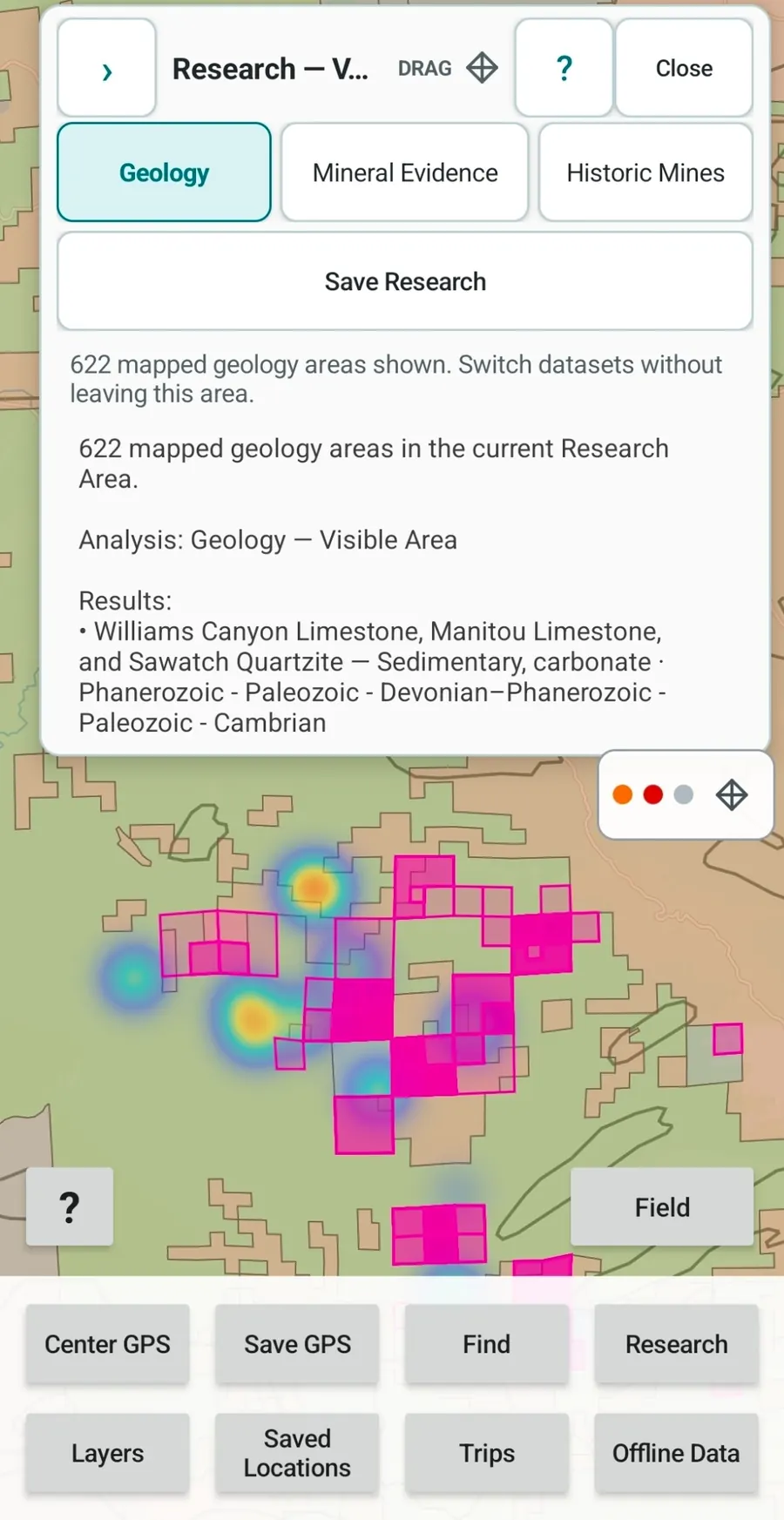
Search Colorado geology by term, lithology or age, inspect the units in the current map area, and compare the mapped geology with Mineral Evidence and historic mine records without rebuilding the search in separate apps.
TURN RESEARCH INTO AN AREA
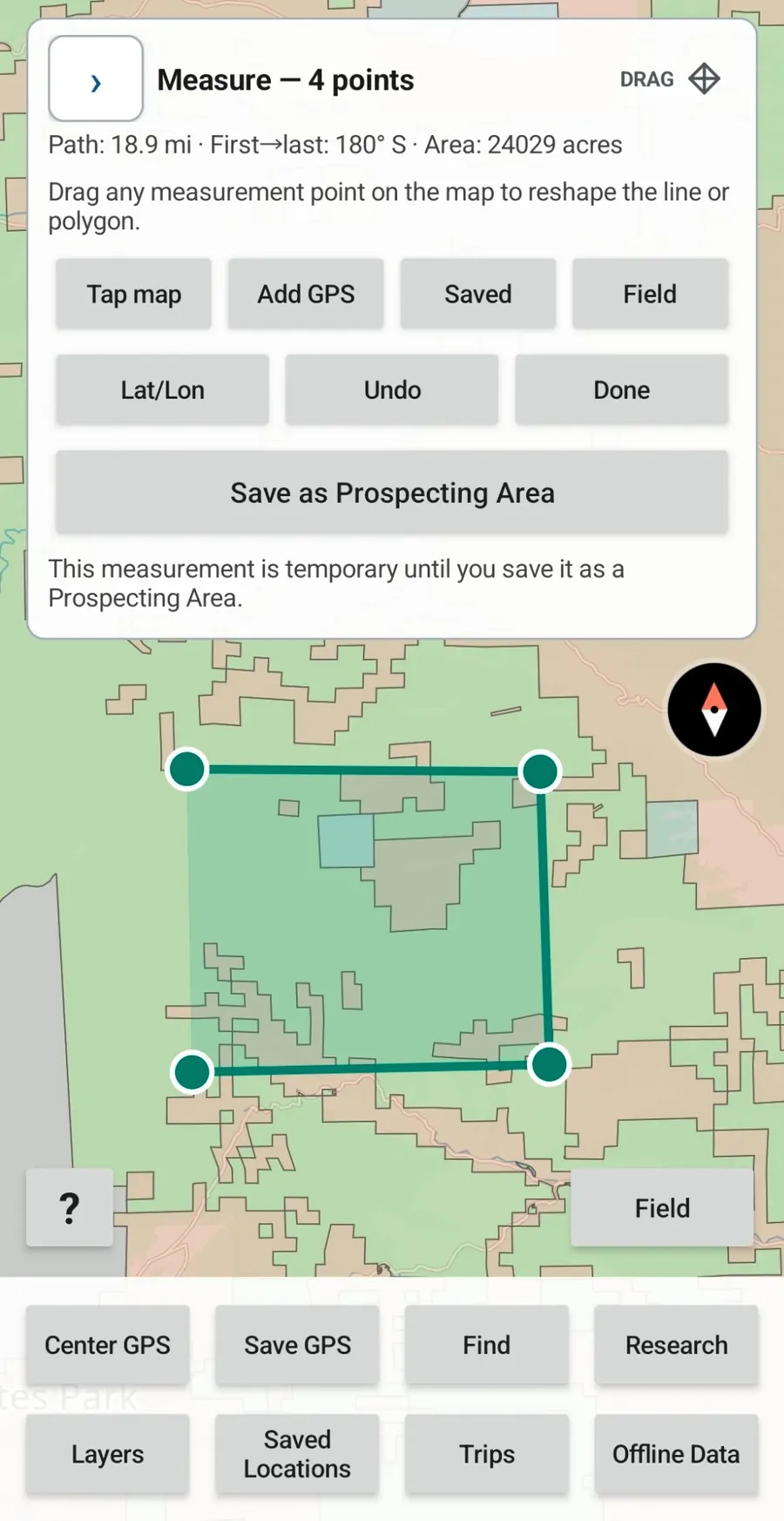
Colorado prospecting rarely fits neatly into one pin. Draw the ground you want to compare, measure it, save it as a Prospecting Area, and use that boundary for mineral, geology and historic-mine research. It can be a creek drainage, a group of slopes, part of an old district or a larger patch of public-land country.
Adjust the boundary as your research changes, then reopen the saved Prospecting Area for further investigation.
Prospecting Areas are research regions, not legal property or claim boundaries.
THE SOURCE IS PART OF THE MAP
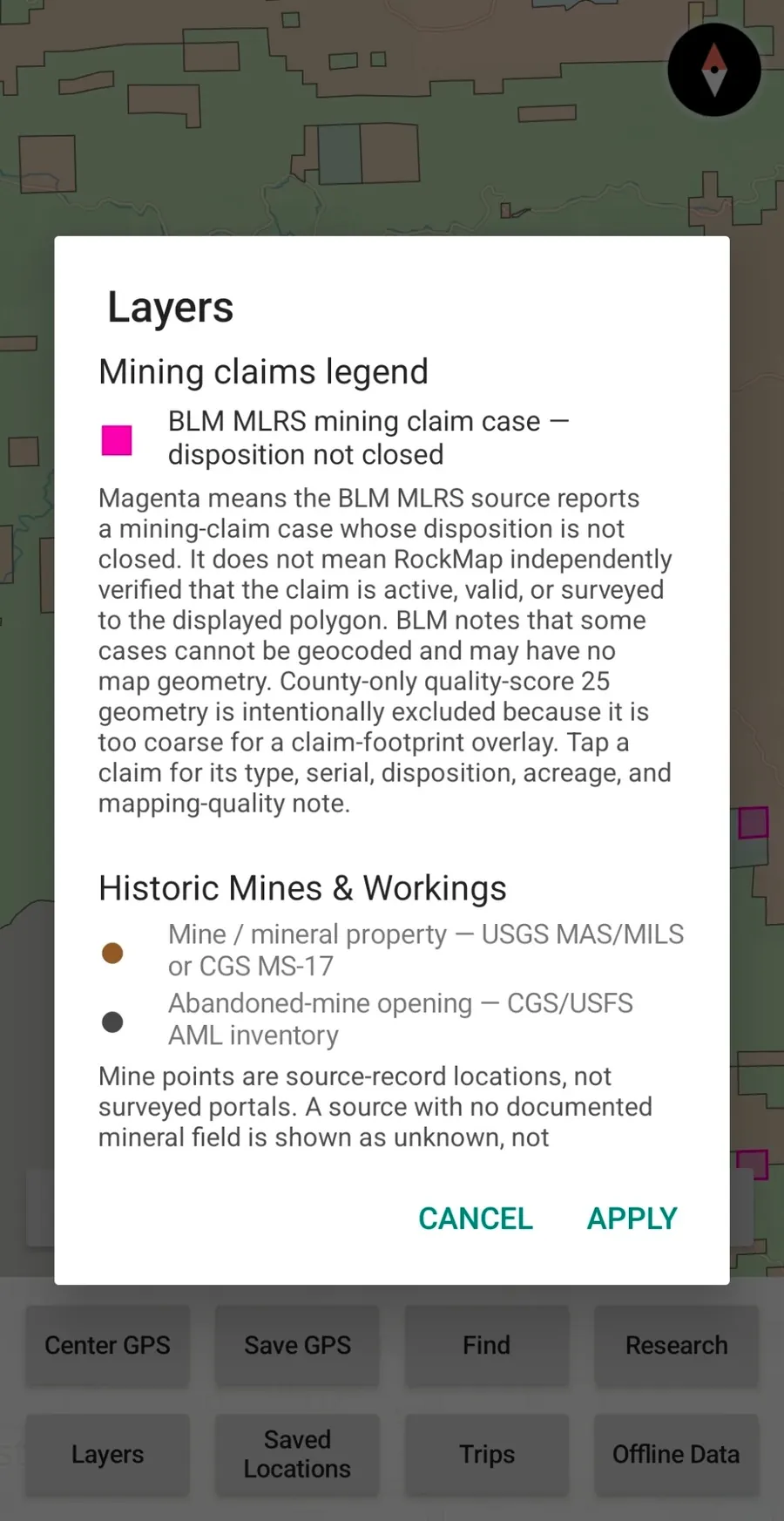
GroundRove’s Layers screen explains where claim, geology and historic-mine data comes from, what the symbols represent and what the source records can and cannot establish.
Colorado has old mine records, generalized geologic mapping, claim geometry and land-management boundaries that can look more exact than the source actually is. GroundRove keeps those qualifications next to the layer.
WHERE THE COLORADO DATA COMES FROM
The Colorado package combines federal and state mineral, mine, claim, geology, land-management and basemap data. The Data Sources page identifies the underlying datasets and the limits that matter when interpreting them.
U.S. BUREAU OF LAND MANAGEMENT
BLM MLRS contributes Mining Claims — Not Closed records and mapped geometry where available. BLM Colorado Surface Management Agency data supplies land-management context.
USGS + FORMER U.S. BUREAU OF MINES
Federal mineral-property, occurrence and mine records contribute to Mineral Evidence and Historic Mines & Workings in Colorado.
COLORADO GEOLOGICAL SURVEY + USGS SGMC
Colorado Geological Survey datasets add state-specific mineral and historic-mining records. The fixed Colorado geology snapshot is derived from the USGS State Geologic Map Compilation.
OPENSTREETMAP + PROTOMAPS
OpenStreetMap-derived data delivered through Protomaps provides roads, paths, water, names and other geographic context alongside GroundRove’s research layers.
WHAT IS PLANNED NEXT
Colorado and Arizona are now part of GroundRove. Future work includes additional states, more map options, more field context and deeper research tools. Founding Access customers receive future GroundRove upgrades as they are released.
EXPANSION
Planned state research packages after Colorado and Arizona. Coverage will be added as the required geology, mineral, claim, land and basemap data are ready for the same offline workflow.
MAPS
Add detailed topographic mapping directly to GroundRove’s research and offline field workflow.
MAPS
Add satellite map options for comparing terrain, access, disturbance, vegetation and other visible ground conditions with GroundRove’s research layers.
TERRAIN
Inspect terrain and surrounding landforms in three dimensions when elevation and physical geography are useful to the research.
RESEARCH
Add fossil occurrence and paleontological datasets so documented fossil evidence can be researched alongside minerals and mining history.
ROCKHOUNDING
Add established collecting locations as another research layer. A known site can be used as a reference point while you examine the geology, mineral evidence, mines, claims and surrounding ground.
LAND RESEARCH
Planned cadastral parcel boundaries and available ownership information for more detailed land research than broad public/private status alone.
FIELD PLANNING
Show camping options around research areas so trip planning stays connected to the map.
FIELD CONDITIONS
Add forecasts and recent weather information where conditions can affect access or field work.
IDENTIFICATION
Add photo-assisted identification tools for specimens found in the field.
TRIP PLANNING
Add nearby fuel, food, lodging and other practical stops around a research area.
RESEARCH
Add more ways to query, filter, compare and cross-reference mineral evidence, geology, mining history, claims and future datasets.
FIELD
Expand what can be measured, recorded, imported, exported and organized while working outside.
PRODUCT
Continue improving the map, Research workflow, Layers system, offline controls and Field interface while adding useful geological, mineral, land and field datasets.
LIMITED-TIME FOUNDING ACCESS
The $55 Founding Access includes Colorado and Arizona now, plus future GroundRove upgrades and planned state expansions as they are released.
Planned features and state expansions may change during development and do not have guaranteed release dates.
GROUNDROVE FOUNDING ACCESS
Colorado and Arizona are included. Future GroundRove upgrades and planned state expansions are included with the lifetime Founding Access.
FOUNDING LICENSE
one time · lifetime access
Use GroundRove for 7 days. Cancel before the trial ends to avoid the $55 one-time charge.
After the $55 lifetime purchase, you have 7 days to request a 100% refund.
BEFORE YOU BUY
The trial lasts 7 days. Unless you cancel before it ends, your payment method is automatically charged $55 once for lifetime GroundRove access. After that purchase, you have 7 days to request a 100% refund. There is no recurring subscription.
No. $55 lifetime is the introductory GroundRove Founding Access. After the founding period, regular pricing for new customers will be $55/year. Founding customers remain on lifetime access.
No. Founding Access includes future GroundRove upgrades and planned state expansions. Colorado and Arizona are included now.
Yes. GroundRove’s installed Colorado maps and research datasets remain available offline, and GPS-based field tools continue working without cellular service.
GroundRove shows public and private land-status context. It does not currently provide cadastral private-parcel boundaries and should not be treated as a legal property survey.
Yes. GroundRove includes BLM MLRS claim records and mapped geometry where available. A blank map is not legal proof that ground is unclaimed, and mapped claim geometry is not a surveyed legal boundary.
They visualize the density and strength of documented mineral/material evidence in the source records for an area. They are research tools, not probability maps and not predictions of what you will find.
Colorado sources include BLM MLRS mining-claim records, BLM Colorado Surface Management Agency data, federal mineral and mine records, Colorado Geological Survey datasets, USGS SGMC geology, and OpenStreetMap-derived basemap data through Protomaps. The Data Sources page lists datasets and limitations in more detail.
No. GroundRove provides research context including land status and claim records. You still need to verify agency rules, restrictions, legal records and landowner permission for a specific site.
COLORADO RESEARCH + OFFLINE FIELD USE
Use mineral evidence, Colorado geology, historic mining records, BLM mining claims and land status to research areas before a trip, then carry the same map and installed data into the field offline.