
U.S. BUREAU OF LAND MANAGEMENT
Mining claims + land management
BLM MLRS contributes Mining Claims — Not Closed records and mapped geometry where available. BLM Colorado and Arizona Surface Management Agency data supplies land-management context.
COLORADO + ARIZONA · MINING CLAIMS · DEEP RESEARCH · OFFLINE GPS
GroundRove combines current BLM mining-claim records, mineral evidence, state geology, historic mines and land status so you can investigate places that may never appear on a rockhounding list. Colorado and Arizona are available now. Research an area, see what is documented there, check the claims and land around it, save promising ground, then take the same map and research with you offline.
FOUNDING OFFER
Comparable paid mapping apps are roughly $40–$100/year.
Future GroundRove upgrades included · No annual GroundRove membership fee
Colorado and Arizona are included now. Founding Access also covers future planned state expansions.
DISCOVER AREAS FOR YOURSELF
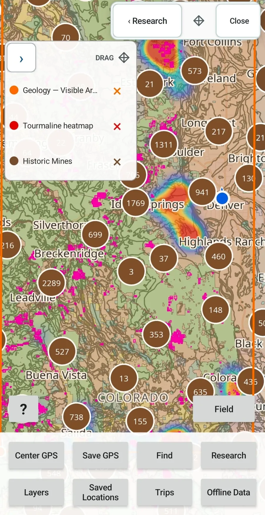
Known rockhounding locations tell you where people have already looked. GroundRove is built to help you investigate the rest of the map. Move to an area in Colorado or Arizona and examine the mineral evidence, geology, historic mining activity, BLM mining claims and land status around it. Start with a mineral, a geologic unit, an old mining district, a place on the map or simply an area that looks worth investigating.
BLM MINING CLAIMS + LAND STATUS
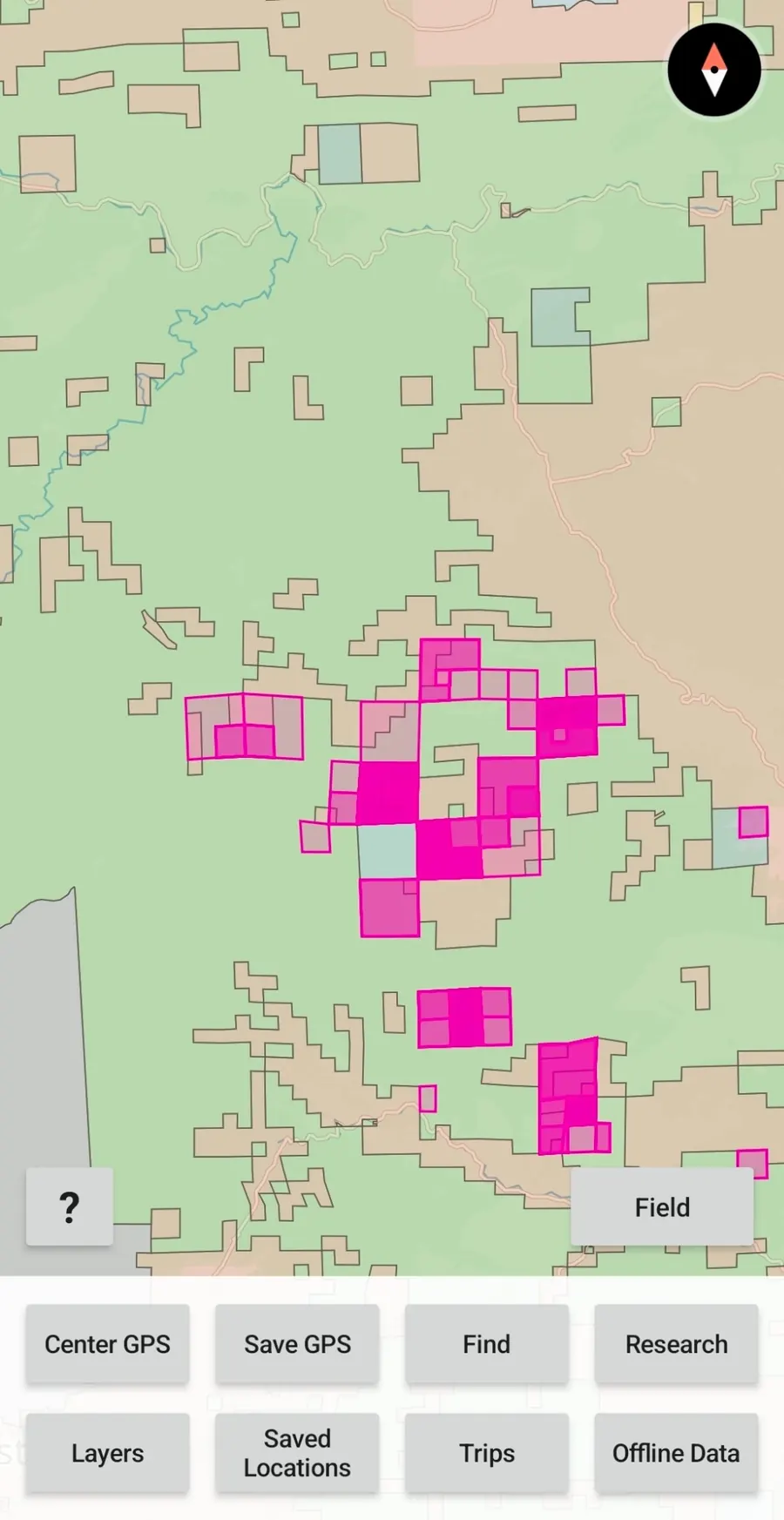
GroundRove puts BLM MLRS mining-claim records on the same map as the geology and mineral evidence you are researching. When an area starts looking interesting, you do not have to leave the research workflow to see the claim record and surrounding land context.
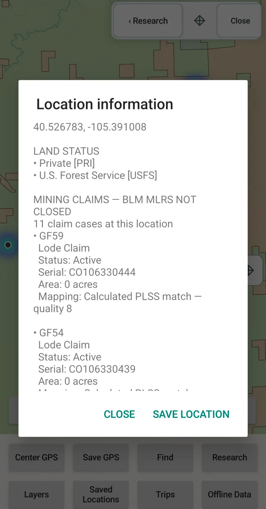
Tap a location to inspect available claim details, including claim type, status, serial information, acreage and mapping-quality information.
Claim geometry is research context, not a surveyed legal boundary. Land status does not independently establish legal access or collecting permission.
FOUNDING OFFER
Get lifetime GroundRove access for $55 once. Comparable paid mapping apps are roughly $40–$100/year. Try GroundRove free for 7 days, and after purchase you have 7 days to request a 100% refund.
MINERAL EVIDENCE RESEARCH
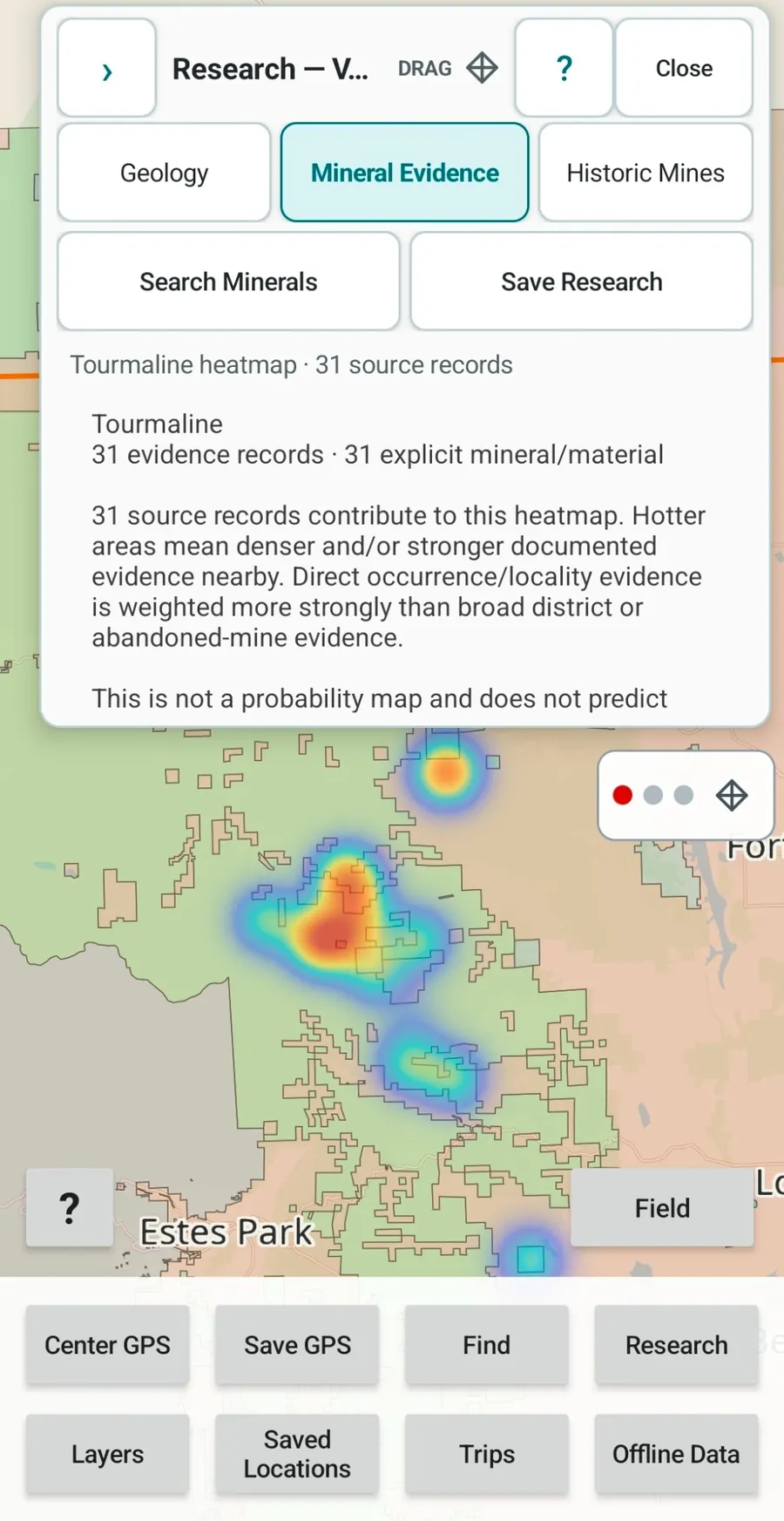
Choose a mineral or material and analyze the area on your screen. GroundRove turns the underlying source records into a geographic evidence heatmap so you can see where documented evidence becomes stronger or more concentrated.
Open the records behind the pattern instead of treating every point equally. Direct occurrences, mineral localities, historic mining records and broader district evidence can tell you different things about an area.
Mineral Evidence shows documented evidence. It does not predict that you will find a mineral at a location.
The Founding Access is $55 once for lifetime access—not another annual mapping subscription. Start with a 7-day free trial; after purchase, you have 7 days to request a 100% refund.
SIDE BY SIDE
Some rockhounding apps are built primarily around established collecting locations. GroundRove is built around investigating arbitrary ground: mineral evidence, geology, historic mining activity, BLM mining claims and land context are brought together so you can decide where you want to investigate next. Known rockhounding locations are planned for GroundRove too, but they will become another research layer rather than replacing the deeper research workflow.
The full table sits here—after the core research differentiators and before the rest of the field workflow and the Founding Access details.
GroundRove feature names below match the labels used in the app wherever possible.
| Capability | GroundRoveGroundRoveFounding Access | RockHoundRRockHPro | RockdRockdFree | MindatMindatFree | onX BackcountryonX BCElite | Gaia GPSGaiaPremium | OsmAndOsmAndPro | Avenza MapsAvenzaPlus | CalTopoCalTopoPro | BaseMapBaseMapPro | LandGlideLandGPersonal | onX HuntonX HuntPremium · 1 state |
|---|---|---|---|---|---|---|---|---|---|---|---|---|
| Dedicated mobile app | ✓ | ✓ | ✓ | — | ✓ | ✓ | ✓ | ✓ | ✓ | ✓ | ✓ | ✓ |
| Comparable price | $55 oncelifetime access*7-day free trial | $49.99/yrPro† | Freeno paid tier | Freemembership free | $99.99/yrElite‡ | $59.99/yrPremium | $39.99/yrPro · US App Store | $34.99/yrPlus§ | $50/yrPro | $39.99/yrPro | $99.99/yrPersonal | $34.99/yrPremium · 1 state¶ |
| Analyze visible mineral evidence | ✓ | — | — | ◐ | — | — | — | — | — | — | — | — |
| Search minerals / materials | ✓ | ✓ | — | ✓ | — | ✓ | ↗ | ↗ | ↗ | — | — | — |
| Mining claims | ✓ | ◐ | — | ◐ | — | — | ↗ | ↗ | ↗ | — | — | ◐ |
| Historic mines & prospects | ✓ | ◐ | — | ✓ | — | ✓ | ↗ | ↗ | ↗ | — | — | — |
| Colorado geology | ✓ | ◐ | ✓ | ◐ | — | ✓ | ↗ | ↗ | ✓ | — | — | — |
| Search & explore geology | ✓ | ◐ | ✓ | ◐ | — | ◐ | ↗ | ↗ | ◐ | — | — | — |
| Analyze current map area | ✓ | — | ◐ | ◐ | — | — | ↗ | ↗ | — | — | — | — |
| Geology filters | ✓ | — | ◐ | ◐ | — | — | ↗ | ↗ | — | — | — | — |
| Geology + Mineral Evidence | ✓ | ◐ | — | ◐ | — | ◐ | ↗ | ↗ | ↗ | — | — | — |
| Research results on the map | ✓ | ◐ | ◐ | ◐ | — | — | ↗ | ↗ | — | — | — | — |
| Land management | ◐ | ◐ | — | — | ◐ | ✓ | ↗ | ↗ | ✓ | ✓ | ✓ | ✓ |
| Offline maps + GPS | ✓ | ✓ | ◐ | ◐ | ✓ | ✓ | ✓ | ✓ | ✓ | ✓ | ✓ | ✓ |
| Track & backtrack + saved field data | ✓ | ◐ | ◐ | ◐ | ✓ | ✓ | ✓ | ✓ | ✓ | ✓ | ◐ | ✓ |
| Import / export data | ✓ | ◐ | — | — | ◐ | ✓ | ✓ | ✓ | ✓ | ◐ | ◐ | ✓ |
Comparable pricing: GroundRove $55 once for lifetime Founding access, with a 7-day free trial and a 7-day 100% refund period after purchase; RockHoundR Pro $49.99/year; Rockd free; Mindat free; onX Backcountry Elite $99.99/year; Gaia GPS Premium $59.99/year; OsmAnd Pro $39.99/year in the U.S. App Store; Avenza Maps Plus $34.99/year; CalTopo Pro $50/year; BaseMap Pro $39.99/year; LandGlide Personal $99.99/year; onX Hunt Premium $34.99/year for one state.
Pricing checked August 30, 2026. Main cells use regular annual/list pricing for the paid tier that most closely matches the capabilities represented in this chart; temporary first-year promotions and monthly billing are not used as the headline comparison. *GroundRove includes a 7-day free trial, then $55 lifetime as the introductory Founding Access, followed by 7 days to request a 100% refund after purchase; after the founding period, regular pricing for new customers becomes $55/year, while Founding customers remain lifetime and receive future GroundRove upgrades. †The U.S. App Store currently lists RockHoundR Pro yearly purchases at both $49.99 and $29.99; $49.99 is used as the primary current annual listing here, but an alternate/legacy offer may be available. ‡onX Backcountry Elite is $99.99/year at regular renewal pricing and is the tier that adds private land boundaries and landowner names; a temporary $30 first-year promotion is currently advertised. §Avenza Plus is the recreational tier at $34.99/year; Avenza Pro is a much more expensive professional/commercial tier and is not used for this consumer comparison. ¶onX Hunt Premium is $34.99/year for one state; Elite is $99.99/year for all 50 states plus Canada and additional tools. RockHoundR features were checked against its official website, current App Store / Google Play materials and current in-app behavior on August 30, 2026; other competitor features were previously checked against official product/help/store materials. “Not documented” means the reviewed official materials did not establish a comparable built-in feature. Promotions and product terms can change.
THE REST OF THE MAP IS STILL THERE
Comparable paid mapping apps are roughly $40–$100/year. GroundRove Founding customers pay $55 once, keep lifetime access and receive future GroundRove upgrades.
OFFLINE GPS + FIELD TOOLS
GroundRove's installed Colorado and Arizona maps and research datasets stay available offline on your phone. The GPS and field workflow keep working when cellular service is gone, so the same app you used to research a place is the one you carry into it.
OFFLINE IN COLORADO
$55 once keeps GroundRove for life, including future upgrades and offline field tools. Start with a 7-day free trial; after purchase, you have 7 days to request a 100% refund.
GO DEEPER THAN THE MINERAL RECORD
A mineral record tells you something was documented somewhere. Geology can help you investigate why it was there and what else nearby deserves attention.
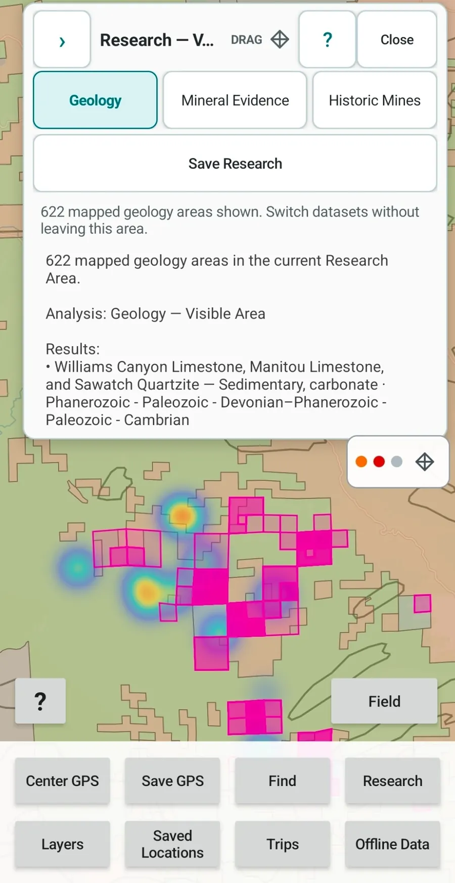
Search installed Colorado or Arizona geology, inspect units in the current map area, and move between geology, Mineral Evidence and historic mining records without rebuilding the search in separate apps.
TURN RESEARCH INTO AN AREA
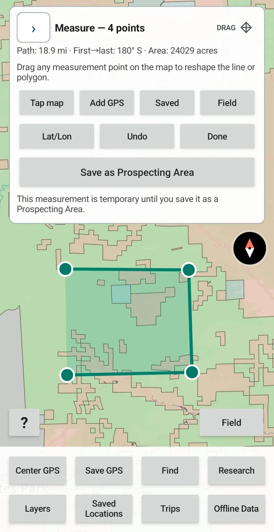
GroundRove does not force your research into individual pins. Draw the ground you actually want to investigate, measure it, save it as a Prospecting Area, and use that boundary for further mineral, geology and historic-mine research.
Adjust the boundary as your research changes, then reopen the saved Prospecting Area for deeper investigation.
Prospecting Areas are research regions, not legal property or claim boundaries.
THE SOURCE IS PART OF THE MAP
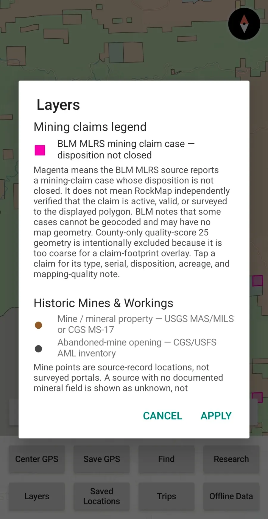
GroundRove's Layers screen explains where claim and historic-mine data comes from, what the symbols represent and the limits of what the source records can prove.
This matters in field research. A mapped claim polygon is not automatically a surveyed legal boundary. A mine point can be a source-record location rather than a surveyed portal. GroundRove puts those qualifications next to the layer.
WHERE GROUNDROVE GETS ITS DATA
GroundRove packages federal and state mineral, mine, claim, geology, land-management, place-name and basemap data for offline research. The Data Sources page identifies the underlying datasets and the limits that matter when interpreting them.
U.S. BUREAU OF LAND MANAGEMENT
BLM MLRS contributes Mining Claims — Not Closed records and mapped geometry where available. BLM Colorado and Arizona Surface Management Agency data supplies land-management context.
U.S. GEOLOGICAL SURVEY + FORMER USBM
USGS MRDS and historic MAS/MILS records contribute mineral-occurrence and mine research context. Arizona Past Producer MRDS records support Historic Mines & Workings.
USGS SGMC + USGS CNGM
Colorado queryable geology is derived from USGS SGMC. Arizona queryable geology is derived from the USGS Cooperative National Geologic Map (CNGM), Earth’s surface geology.
COLORADO GEOLOGICAL SURVEY
Colorado Geological Survey datasets add state-specific mineral, district, locality and historic-mining context where included.
OPENSTREETMAP + PROTOMAPS / USGS GNIS
OpenStreetMap-derived data delivered through Protomaps provides offline basemap context. USGS GNIS contributes place-name reference data where included.
WHERE GROUNDROVE IS GOING
GroundRove will keep expanding both sides of the app: deeper ways to research unfamiliar ground before a trip, and better tools for actually using that research outside. Founding Access customers receive future GroundRove upgrades as they are released.
EXPANSION
Colorado and Arizona are available now. California, Utah and New Mexico are planned as the required geology, mineral, claim, land and basemap data are prepared for the same offline workflow.
MAPS
Add detailed topographic mapping directly to GroundRove’s research and offline field workflow.
MAPS
Add satellite map options for comparing terrain, access, disturbance, vegetation and other visible ground conditions with GroundRove’s research layers.
TERRAIN
Explore terrain and surrounding landforms in three dimensions when elevation and physical geography are useful to understanding an area.
RESEARCH
Add fossil occurrence and paleontological datasets so areas can be researched for documented fossil evidence in addition to minerals and mining history.
ROCKHOUNDING
Add established collecting locations as another research layer—not as the boundary of where GroundRove can search. Use a known location as a reference point, then examine the mineral evidence, geology, mines, claims and surrounding ground to look beyond it.
LAND RESEARCH
Planned support for cadastral parcel boundaries and available ownership information, so GroundRove can eventually show more than broad public/private land status when researching an area.
FIELD PLANNING
Show camping options around areas being researched so field-trip planning remains connected to the map.
FIELD CONDITIONS
Add useful field conditions and forecasts to the areas you are researching, including recent weather where it can affect access or field conditions.
IDENTIFICATION
Add photo-assisted identification tools for specimens found in the field, including rocks, minerals and fossils.
TRIP PLANNING
Add useful nearby services and field logistics such as fuel, food, lodging and other practical stops around a research area.
RESEARCH
Add more ways to query, filter, compare and cross-reference mineral evidence, geology, mining history, claims and future datasets.
FIELD
Expand what you can navigate, measure, record, import, export and organize while working outside.
PRODUCT
Continue improving the map, Research workflow, Layers system, offline controls and Field interface while adding useful geological, mineral, land and field datasets.
LIMITED-TIME FOUNDING LICENSE
Comparable paid mapping apps are roughly $40–$100/year. The $55 Founding Access stays lifetime and includes future GroundRove upgrades, including planned new states and features as they are released.
Planned features may change during development and do not have guaranteed release dates.
GROUNDROVE FOUNDING ACCESS
Future upgrades are included. Colorado and Arizona are included now, and your lifetime Founding Access includes future GroundRove upgrades and planned state expansions.
FOUNDING LICENSE
one time · lifetime access
Use GroundRove for 7 days. Cancel before the trial ends to avoid the $55 one-time charge.
After the $55 lifetime purchase, you have 7 days to request a 100% refund.
Saving a payment method does not start the trial clock. The 7-day trial begins when you first activate GroundRove in the Android app.
BEFORE YOU BUY
Saving a payment method does not start the trial. The 7-day trial begins when you first activate GroundRove in the Android app. Unless you cancel the scheduled purchase before the trial ends, your saved payment method is charged $55 once for lifetime GroundRove access. After that successful purchase, you have 7 days to request a 100% refund. There is no recurring subscription.
No. $55 lifetime is the introductory GroundRove Founding Access. After the founding period, regular pricing for new customers will be $55/year. Founding customers remain on lifetime access.
No. Founding Access includes Colorado and Arizona now, plus future GroundRove upgrades and planned state expansions.
Yes. GroundRove's installed Colorado and Arizona maps and research datasets remain available offline, and GPS-based field tools continue working without cellular service.
GroundRove shows public and private land-status context. It does not currently provide cadastral private-parcel boundaries and should not be treated as a legal property survey.
Yes. GroundRove includes BLM MLRS claim records and mapped geometry where available. A blank map is not legal proof that ground is unclaimed, and mapped claim geometry is not a surveyed legal boundary.
They visualize the density and strength of documented mineral/material evidence in the source records for an area. They are research tools, not probability maps and not predictions of what you will find.
Sources include BLM, USGS, the Colorado Geological Survey, former U.S. Bureau of Mines source records where incorporated, and OpenStreetMap-derived basemap data through Protomaps. Colorado geology uses USGS SGMC; Arizona geology uses USGS CNGM. The Data Sources page lists datasets and limitations in more detail.
No. GroundRove provides research context including land status and claim records. You still need to verify agency rules, restrictions, legal records and landowner permission for a specific site.
RESEARCH FIRST · THEN GO LOOK
Use mineral evidence, state geology, historic mining records, BLM mining claims and land status to investigate areas in Colorado or Arizona, then carry the same map and research into the field offline.